
Hurricane isaias
Moderate-High: Hurricane Isaias Expected to Strengthen Before Landfall Late Friday
FMIT will host a Hurricane Preparedness Webinar tomorrow, Friday, October 9th, at 10:00 AM EDT. Members are encouraged to attend for the latest storm projections, preparedness guidance, and FMIT available resources. Click Here to Register.
Hurricane Isaias continues to strengthen in the central Gulf of America. As of 2:00 PM EDT, Isaias has maximum sustained winds near 85 mph and is moving east-northeast at 10 mph. Additional strengthening is expected through early Friday. Isaias is forecast to turn northeast tonight and north on Friday, making landfall within the warning area late Friday or early Saturday as a dangerous hurricane.
Hurricane, tropical storm, and storm surge warnings remain in effect for the Florida Panhandle and Big Bend, and the Storm Surge Warning has been extended east to the Suwannee River. Tropical storm conditions are expected to begin on Friday, with hurricane conditions Friday night into early Saturday. Rainfall forecasts have also increased, with localized totals up to 15 inches possible across the Florida Panhandle and Big Bend. Members in the warning areas should complete facility preparations before winds arrive on Friday, coordinate closely with local emergency management, and be ready to activate continuity of operations plans for possible long-duration power outages and significant flooding.
FMIT Rideout Teams are preparing for deployment, with the Recovery Operations Center set for activation on Friday, October 9th. The FMIT EOC is also preparing for activation.
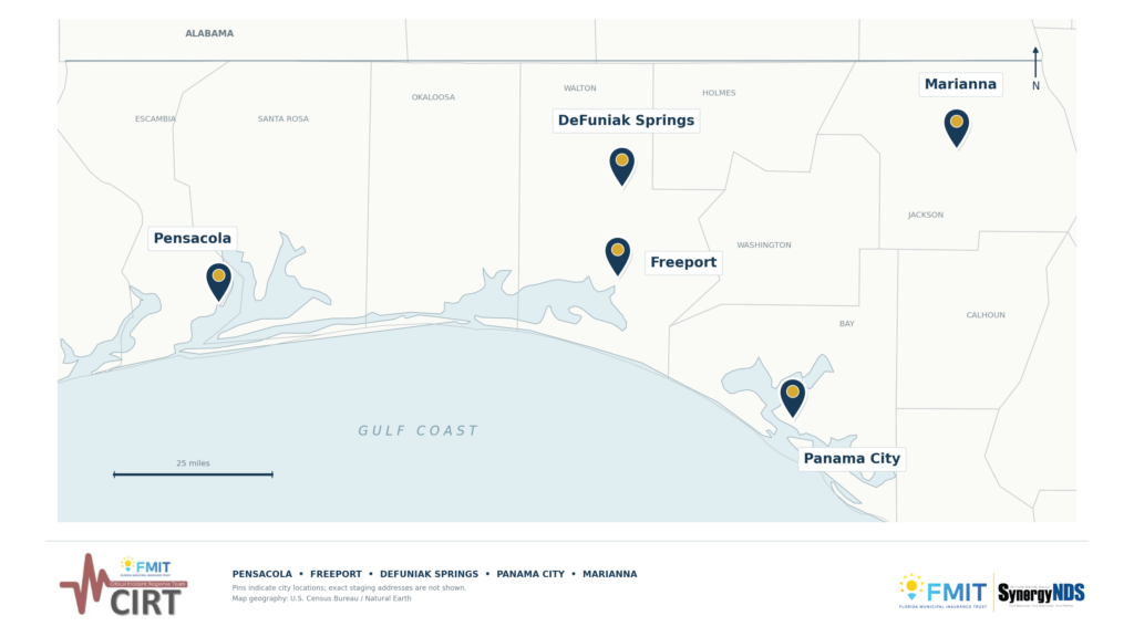
The below map displays the pre-determined areas where Damage Assessment Rideout Teams will be deployed.
Mitigation Matters
Prompt mitigation and stabilization of damaged facilities are key to a successful recovery. Acting quickly helps:
- Prevent secondary damage, such as water intrusion and mold
- Shorten the recovery timeline
- Minimize disruption to essential operations
FMIT and Synergy have resources on standby to assist. Report damages to FMIT as soon as it is safe to do so to access support through the FMIT TurnKey Recovery Program.
*This alert is sent to members of the Florida Municipal Insurance Trust (FMIT) as part of their industry-leading property insurance recovery program. These alerts keep FMIT Members aware of impending events as well as provide strategic and tactical information with regard to FMIT response activity in the event of a disaster.
Call 844-FMIT-CAT (844-364-8228)
to contact the FMIT Claims Center Hotline.
Email [email protected]
to send damage related emails to FMIT Claims Center.
FMIT Member:
4:00 PM EDT, Thursday, October 8th, 2026
FMIT Discussion:
- Hurricane Isaias is in the central Gulf of America with maximum sustained winds near 85 mph, moving east-northeast at 10 mph. Additional strengthening is expected through early Friday.
- Isaias is expected to turn northeast tonight and north on Friday, making landfall along the northern Gulf Coast within the warning area late Friday or early Saturday.
- A Hurricane Warning is in effect from the Alabama–Florida border to the Bay/Gulf County line. Hurricane conditions are expected Friday night into early Saturday.
- A Tropical Storm Warning is in effect from east of the Bay/Gulf County line to the Aucilla River. Tropical storm conditions are expected Friday and Friday night.
- The Storm Surge Warning now extends from the Alabama–Florida border to the Suwannee River, and a Storm Surge Watch is in effect from the Suwannee River to Yankeetown. Peak surge forecasts are:
-
- Alabama–Florida border to Indian Pass: 5–7 ft
-
- Indian Pass to Steinhatchee River: 4–6 ft
-
- Steinhatchee River to Suwannee River: 3–5 ft
-
- Suwannee River to Yankeetown: 2–4 ft
- Rainfall of 3–7 inches is forecast from the Florida Panhandle to the Big Bend Friday through the weekend. Localized totals up to 15 inches are possible. Considerable flash and urban flooding is possible across the Florida Panhandle, and significant river flooding is also possible.
- Isolated tornadoes are possible Friday night in the Florida Panhandle and Saturday across northern Florida.
- Life-threatening surf and rip currents are expected along the Gulf Coast beginning Friday.
- FMIT Rideout Teams are preparing for deployment, with the Recovery Operations Center set for activation on Friday, October 9th. The FMIT EOC is also preparing for activation.
FMIT Member Preparedness Actions:
- Members in warning areas should rush facility preparations to completion today, before tropical-storm-force winds arrive on Friday.
- Coordinate closely with local emergency management, and ensure the safety of staff and essential personnel.
- Activate continuity of operations plans and confirm emergency staff contacts and communication procedures.
- Secure facilities, loose outdoor items, and equipment. Move vehicles and equipment out of surge-prone and flood-prone areas.
- Clear storm drains, gutters, scuppers, and roof drains ahead of heavy rainfall and potential flooding.
- Test generators and confirm fuel supplies ahead of expected long-duration power outages.
- Members should continue to monitor Hurricane Isaias as well as FMIT Alerts and local/national weather forecasts.
Copyright © 2026 FMIT, All rights reserved.